
The following field definitions are organized as they appear in the issue record dialogue box.
FDOT District – CFID includes records of freight mobility issues in two FDOT districts: District 1 (Manatee, Polk, and Sarasota Counties only) and District 7 (Citrus, Hernando, Hillsborough, Pasco, and Pinellas Counties). The DISTRICT field provides information about which district a given CFID issue falls into and enables querying of CFID issues by district location.
COUNTY – The COUNTY field identifies the county in which a CFID issue is located and allows querying of CFID issues by county location.
CORRIDOR – This is the name of the roadway corridor on which the CFID issue is located. The CORRIDOR NAME is provided as the state road number or local street name on which the issue is found. The following examples show the conventions that should be used in naming roads in CFID. State routes should be shown as SR and then followed by the route number. United States highway numbers should be shown after the state route number where applicable. The word highway should be excluded from the name (e.g. US 301 and not US Highway 301). If there is a common name for a roadway that is on the state system, it should be listed at the end of the name. Local roads should be given their full name without shortening the road type (e.g. road, street, and boulevard). Roads with cardinal directions associated with them should include the shortened version of the cardinal direction with the letters entered as all capitals (e.g. N, W, NE). Please note that the Road From and To’s descriptions can be submitted in the “Segment From” and “Segment To” data fields.
Corridor Road naming includes the following convention: US Route, State Route, County Road, and Local Name – Road Name to Road Name
Example US Route/State Road/Local Corridor Segment: US 41/SR 55/– 14th Street W to 9th Street
EXTENT – During data collection, CFID issues were categorized as being located throughout a corridor or at a specific location. The EXTENT field allows querying of CFID issues by this classification of the issue extent.
• Corridor issues define needed improvements that apply consistently along a length of roadway between the limits specified in the SITE LOCATION field. For example, a signal optimization improvement that accounts for the unique operating characteristics of trucks (slow acceleration and deceleration times, e.g.) would be identified for and applied to a corridor. Cartographically, corridor issues are portrayed as linear features.
• In contrast, specific location issues apply only to a particular geographic point, often an intersection, at which a needed freight mobility improvement has been identified. For example, a narrow turn radius at the southeast corner of an intersection that impedes truck turning movements from the northbound approach lanes to the eastbound receiving lanes would be classified as specific location issue. Cartographically, specific location issues are portrayed as point features.
SITE NAME/LOCATION – This is the location (segment or intersection) at which the freight issue was identified. Typically, the SITE DESCRIPTION is provided as the state road number (or local road name) with information about the location of the issue as bounding or intersecting street segments.
Specific Locations Road Naming includes the following convention: US Route, State Route, County Road, and Local Name at Road Name
Example Road Convention Specific Location: US 41/SR 45/CR 683 at 53rd Avenue W
SEGMENT FROM– The SEGMENT FROM fields identify the intersection roadways that are the beginning and ending points for CFID issues associated with roadways segments.
SEGMENT TO – The SEGMENT TO fields identify the intersection roadways that are the beginning and ending points for CFID issues associated with roadways segments.
ISSUE SITE LOCATION – Used in reference to the SITE DESCRIPTION field, the ISSUE SITE LOCATION field provides detailed information about where the freight issue is located.
Example:
NW corner; NE corner; SW corner; SE corner;
NB approach; SB approach; EB approach; WB approach;
North leg median; South leg median; West leg median; East leg median;
NB lanes; SB lanes; EB lanes; WB lanes
COLLECTION SOURCE OF RECOMMENDATION – Issues identified in the CFID are obtained from a variety of sources, including local and regional transportation plans, surveys of truck drivers, coordination with freight providers, and more. The COLLECTION SOURCE field groups issues by the sources through which they were documented to enhance coordination among state, regional, local, and private stakeholders. Potential sources include:
• FDOT: FDOT continually monitors the performance of the regional transportation system and regularly adds, edits, and archives issues in the CFID as conditions evolve. Records with a COLLECTION SOURCE value of “FDOT” are derived through the Department’s regular maintenance processes and ongoing studies.
• Freight Provider: CFID serves as a vehicle to facilitate ongoing coordination between FDOT, local transportation planners and engineers, and the private sector to ensure that issues affecting everyday goods movement operations are included in the database. Issues identified by intermodal shippers, logistics enterprises, and other freight providers provide valuable information about key improvements and strategies that can support safe and efficient goods movement throughout the region.
• Truck Driver Survey: Surveys are periodically conducted with truck drivers to identify locations where they experience operational problems on the transportation network. These include locations where the existing roadway geometry or traffic operational controls hinder their ability to travel through a corridor or navigate turns at intersections and driveways. These surveys assist to identify freight “hot spots” throughout the region. These locations are then field verified to confirm that a traffic operational problem exists and to identify other potential issues. Unresolved issues identified in the truck driver survey are included in CFID.
• MPO/Local Government: Local jurisdictions and MPOs are encouraged to utilize CFID to highlight issues affecting goods movement in their areas. Records obtained from these sources provide valuable insight into the long term transportation plans and community development goals that are shaped at the local level.
• Screening Reports: Freight corridor screenings are periodically conducted on components of the defined regional freight roadway network in the eight-county region studied in the Tampa Bay Regional Strategic Freight Plan (2012). The screenings are used to identify potential issues on freight corridors related to travel conditions and operations. The results of the screenings are uploaded to CFID.
FIELD VERIFIED – As issues are added to CFID, FDOT will undertake field research to verify the information provided. Issues that have been field verified are marked with a check in the “FIELD VERIFIED” field. When querying CFID, users may elect to view only field-verified issues.
PRIORITY – CFID issues are assigned a basic, preliminary priority level based on the kinds of facilities on which an issue has been identified and other factors indicating the significance of the issue to regional goods movement.
• High Priority: High priority should be given to these improvements in FDOT and other transportation project prioritization processes. Integration of improvements into current projects will be actively pursued. Scoping and development of individual project concepts will be commenced by FDOT where opportunity for integration into other projects is not possible. Improvements will be incorporated into planned and programmed projects that occur on the same roadway segment.
• Low Priority: Integration of improvements into current, programmed and planned projects will be actively pursued.
CFID users can query the database to find issues of one or more of these priority levels. Priority levels can change over time depending on planning and policy goals, engineering requirements, feedback from stakeholders, or evolving conditions.
IMPLEMENTAION EASE – Each CFID issue and associated potential improvement or remedy is assessed in terms of its prospective ease of implementation based on observed conditions at the site location. Potential obstacles to implementing recommendations or otherwise addressing the identified issue are inventoried as ISSUE CONSTRAINTS. These obstacles include both right-of-way constraints and physical constraints such as the presence of light poles, signage, structures, or other objects. IMPLEMENTATION EASE is estimated based on the number of constraints observed at the issue location:
• Easy – No constraints were observed that would complicate implementation of a response to the issue.
• Moderate – One or two constraints were observed, posing minor challenges to implementation of a response to the issue.
• Difficult – Constraints were observed such that implementation of a response to the issue would be expected to require substantial planning, coordinated relocation of obstacles and/or significant financial resources.
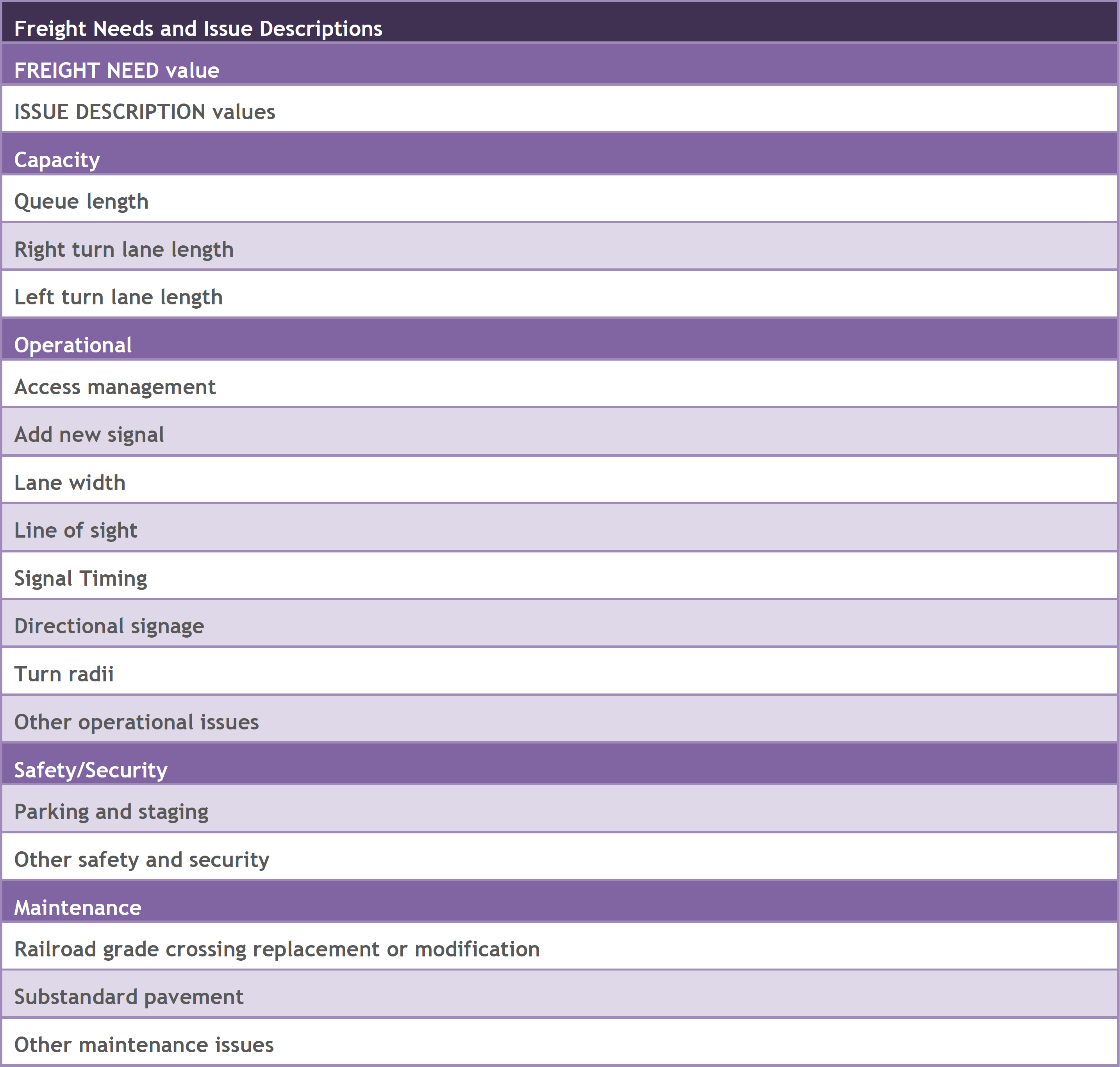
FREIGHT NEED – This is a general description of the type of issue described in the CFID record. The following freight need types are documented in CFID:
• Capacity needs – Capacity needs entail the expansion of an intersection to include additional turn lanes or lengthen queue storage. Capacity needs are generally identified at locations where freight operations are impeded by inadequate space to manage the number of vehicles flowing through an intersection or making a turning movement.
• Operational needs – In many cases, the flow of traffic along a roadway can be improved through operational strategies such as signal timing optimization, improved signage and wayfinding, or enhancements to throughway and/or intersection geometry. From a goods movement perspective, operational improvements account for the unique operational characteristics of trucks – including wide turning movements and slow acceleration times. Addressing truck operational issues along a corridor or at an intersection can significantly improve travel time reliability along a roadway as well as accessibility to industrial and commercial uses.
• Safety/Security needs – CFID includes an inventory of safety and security issues. Safety needs address potential hazards posed by freight operations to industry and/or logistics personnel, non-freight users of the shared transportation network, or property. Security needs address measures taken to protect strategic transportation infrastructure, vehicles, cargoes, and personnel from potential threats posed by nature and people.
• Maintenance needs –The ongoing maintenance of transportation facilities is a significant factor in providing efficient and economical goods movement. Facility maintenance is typically scheduled by implementation agencies, public works departments, private owners (CSXT, e.g.), or port and aviation authorities on a separate basis from capacity and operational improvements implementation. Unlike other types of freight needs, maintenance issues frequently do not require redesign of roadways or intersections, alterations to traffic operations or additional infrastructure. Most maintenance needs address pavement resurfacing and rehabilitation needs.
ISSUE DESCRIPTION – Used in conjunction with the FREIGHT NEED field, ISSUE DESCRIPTION specifies type of issue identified in the CFID record. Valid values depend on the FREIGHT NEED field, as shown in the table below.
Table 1: Types of Freight Needs under Issue Description Field
PRIMARY ROADWAY ID – This is the FDOT roadway ID associated with the primary corridor on which the freight issue is identified. Where ISSUE EXTENT is “corridor,” the primary corridor will be the roadway on which the identified issues were observed. Where ISSUE EXTENT is “specific location,” the primary corridor is the corridor which is more significant in terms of regional goods movement, such as a regional freight mobility corridor. The PRIMARY ROADWAY ID should always consist of eight characters, including leading zeros where applicable.
Example: 02030000
SECONDARY ROADWAY ID – This is the FDOT roadway ID associated with the corridor that intersects the PRIMARY ROADWAY ID corridor at the site where the specific location CFID issue is found. The SECONDARY ROADWAY ID field allows Roadway ID searches to return information about goods movement issues located at intersections of major roadways or at locations where the ROADWAY ID changes on the same corridor. The SECONDARY ROADWAY ID should always consist of eight characters, including leading zeros where applicable.
Example: 02560000
BEGIN MP – This is the milepost at which a corridor issue begins and is used in conjunction with PRIMARY ROADWAY ID and ENDING MP. The BEGIN MP field is referenced in Roadway ID searches. This field is blank for specific location issues.
ENDING MP – This is the milepost at which a corridor issue ends and is used in conjunction with PRIMARY ROADWAY ID and BEGIN MP. The ENDING MP field is referenced in Roadway ID searches. This field is blank for specific location issues.
LOCATION MP – This is the milepost at which a specific location issue is located and is used in conjunction with PRIMARY ROADWAY ID. The LOCATION MP field is referenced in Roadway ID searches. This field is blank for corridor issues.
LATITUDE – This is the latitude coordinate value (in decimal degrees) of the issue location. It is used in conjunction with the LONGITUDE field. The LATITUDE and LONGITUDE fields are used for defining the locations of specific location issues and are especially useful when information from the PRIMARY ROADWAY ID and LOCATION MP fields is not available.
LONGITUDE – This is the longitude coordinate value (in decimal degrees) of the issue location. It is used in conjunction with the LATITUDE field. The LATITUDE and LONGITUDE fields are used for defining the locations of specific location issues and are especially useful when information from the PRIMARY ROADWAY ID and LOCATION MP fields is not available.
YEAR RECOMMENDED – This is the year in which the CFID issue was initially recorded. It is expressed as a four-digit year.
ISSUE CONSTRAINTS –ISSUE CONSTRAINTS are identified through field review, aerial imagery, survey records and similar sources to identify what, if any, conditions exists at the site location that may pose challenges for the implementation of an improvement strategy for the CFID issue. The field includes conditions or objects in the immediate vicinity of the CFID issue that affect the feasibility of implementing a solution. The ISSUE CONSTRAINTS table informs the IMPLEMENTATION EASE field. Multiple constraints may exist at any single location. ISSUE CONSTRAINTS are identified as either being present or not through the use of check boxes next to the constraint type. Possible constraints include:
• Right-of-Way: There are areas where right-of-way is constrained making capacity and other improvements to corridors and intersections difficult and/or costly.
• Utility: There are instances where underground or above ground utilities, such as electrical poles, stormwater, water, sewer and communications, constrain or complicate the ability to demolish existing infrastructure, excavate or perform other site work and construct or modify roadway facilities.
• Light Pole: Light and signal poles may need to be relocated to accommodate enhancements such as widening lanes, adding or extending turning lanes, or augmenting the turning radius at an intersection.
• Signage: Signs and other breakaway objects in the travel envelop may need to be moved and/or reconfigured to accommodate an improvement strategy for the CFID issue.
• Structures: Buildings, bridge supports, and similar structural objects in the immediate vicinity of the CFID issue can represent significant obstacles to implementing an improvement strategy for the CFID issue or limit response options.
• Other: This is any other observed issue that may pose challenges to implementing a solution to the CFID issue.
TRANSPORTATION SYSTEM – This field indicates the designated transportation system on which the CORRIDOR NAME roadway is found. While a given roadway may be designated on multiple systems, a hierarchy is used to group CFID issues into one of the following systems by precedence:
• SIS Corridors and Connectors – Florida’s Strategic Intermodal System includes the state’s largest and most significant commercial service airports, spaceport, deepwater seaports, freight rail terminals, passenger rail and intercity bus terminals, rail corridors, waterways and highways. CFID issues found on a SIS roadway have a value of either “SIS Corridor” or “SIS Connector” in the TRANSPORTATION SYSTEM field regardless of what other transportation systems they are a part of. SIS Corridors connect major origin/destination markets within Florida or between Florida and other states/nations; SIS Connectors connect SIS hubs and corridors.
• NHS – The National Highway System is designated by the Federal Highway Administration and consists of roadways important to the nation’s economy, defense, and mobility. CFID issues found non-SIS NHS roadways have a value of “NHS” in the TRANSPORTATION SYTEM field.
• On System – State Roads – Other state roadways that are not part of the transportation systems listed above are listed as “On System – State Roads” in the TRANSPORTATION SYSTEM field.
• Off System – Local Roads – Local roads that are not part of the state roadway network are listed as “Off System – Local Roads” in the TRANSPORTATION SYSTEM field.
FREIGHT SYSTEM – This is the freight facility type on the regional goods movement highway network on which the CORRIDOR NAME roadway is found. The freight facility types are identified and described in detail in the Tampa Bay Strategic Freight Plan. A hierarchy is used to group CFID issues into one of the following facility types by precedence:
• Limited Access Facility – Interstate highways and other uninterrupted flow facilities with ramp-only access, including toll roads. Limited access facilities are designed to move high volumes of traffic at high speeds over long distances.
• Regional Freight Mobility Corridor – Major highways that offer high volume and high speed service into, out of, and across the region and state. Regional freight mobility corridors (RFMCs) connect the region’s major freight activity centers to each other and other parts of the region, and they carry substantial levels of local and regional truck traffic.
• Freight Distribution Route – Arterials and other major roads that provide internal connections within the region. Freight distribution routes often connect RFMCs to freight activity centers and to each other. They provide local accessibility for short haul truck trips and last-mile connectivity for long haul truck trips. In many areas freight distribution routes are signed truck routes that are not RFMCs or limited access highways.
• Freight Activity Center Street – Local streets that provide connectivity to and from distribution centers, intermodal terminals, and other major truck trip generators. Freight activity center streets accommodate internal circulation within a freight activity center and/or provide last-mile connections to the regional freight network.
RECOMMENDATION – For select CFID issues, recommendations for potential solutions or next steps for addressing the identified issues are articulated in the RECOMMEND DESC field. These recommendations typically follow a field review and provide general guidance about options for resolving the issue. Recommendations vary in their detail and scope from one record to the next.
FIELD OBSERVATIONS – Detailed notes about conditions at the issue location as observed through a corridor screening or other field review. Field notes often describe the context of area in which the issue was observed or include other notes about observed truck volumes or operational challenges. They provide valuable qualitative descriptions of the site that go beyond the form data contained in other fields.
COMMENTS – Statistics, contextual notes, or other information that describe the issue location and/or its environs. The comments field is provided for the inclusion of any pertinent details about the issue that are not included elsewhere in the database.
PROJECT DIALOGUE FUNCTION – The dialogue function is used for Contributors, Editors and Administrators to exchange relevant information about the issue record or location. Guest users are not able to use this functionality. Guest comments can be made through the CFID contact page.