
The map viewer has a synchronized table tool that can be initiated through the button at the bottom left of the page. View the “Attribute Table” by clicking on the Show Table Button located under the filter list ( Figure 9).
Figure 9 – Show Table Button
![]()
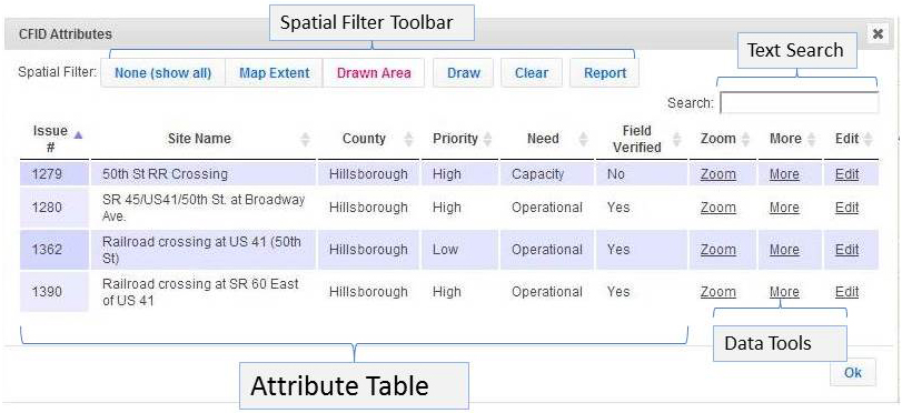
The “Attribute Table” (see Figure 10) has several key functions:
• The table displays the mapped records in a tabular list.
• The table can be arranged dynamically by data field, which can be sorted by clicking the header. Clicking multiple times produces either an ascending or descending ordered list.
• The “Spatial Filter Toolbar” filters the data based on user defined map extent, user drawn graphics, a search text function, and a reporting function. Please reference the list below for specific details about function features.
Functions Included in the “Attribute Table”
Text Attribute Search
Attribute Table Information & Functions
Data Field Sorting
“Zoom To” Feature hyperlink
More Information Dialog window hyperlink
Edit Record Information hyperlink
Spatial Filter Toolbar
Filter by Defined Map Extent
Filter by Custom Drawn Graphic and Filter
Clear Spatial Filter Button
Draw All – Select None Button
Report Output reflecting Records Selection
Figure 10 – “Attribute Table” and “Spatial Filter Toolbar”
The SPATIAL FILTER functions are located at the top left of the “Attribute Table” in the “Spatial Filter Toolbar”
Figure 11 – Spatial Filter Toolbar
![]()